
Flood Room
We provide real-time information to our partners, and co-ordinate the monitoring of flood defences, to support the resilience of communities in the Bay of Plenty.
If you are experiencing flooding in your area, please contact the Duty Flood Manager on +64 7 922 3375.
In an emergency, please ring 111.

What is a Flood Room?
The Flood Room is our dedicated ‘operations hub’, designed to support our flood management team, so they can be effective and efficient when it comes to gathering and sending out timely information.
During a flood, weather events or even periods of heavy rain, the Regional Council flood management team supports a range of agencies (such as emergency services and local councils) with real-time environmental information (such as rainfall data and river levels) that can assist with their planning and response with local communities.
We also have teams in the field, who are inspecting and maintaining the integrity of our flood defences in our rivers and drainage schemes.
The first Regional Council Flood Room was opened in 1995 in Whakatāne. The Flood Room was upgraded in 2020 with investment made into better monitoring and reporting systems, enabling the team to be more responsive to weather events.
How does the Flood Room work?
The Flood Room operates in three modes: ‘Monitoring’, ‘Active Watch’ and ‘Activated’.
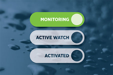
- Status: The weather is looking good and there are no risks of severe weather in the immediate forecast.
- Action: Members of the flood management team (including engineers, rivers and drainage operations, planning and communications) continue their day jobs as part of their everyday mahi at Regional Council. A Regional Council Duty Flood Manager is on call 24 hours a day, maintaining an overview of river levels, weather patterns and forecasts affecting the Bay of Plenty.
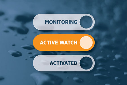
- Status: MetService has issued weather warnings and the weather forecast could impact the community.
- Action: A Regional Council Duty Flood Manager is on call 24 hours a day, maintaining an overview of river levels, weather patterns and forecasts affecting the Bay of Plenty. They will closely monitor the weather situation, the flood forecasts, environmental data and provide real-time information to supporting agencies (such as local councils and Waka Kotahi) to assist with their planning and responding to their communities. The Duty Flood Manager will receive assistance from the wider flood management team as necessary depending on the severity of the flood event.
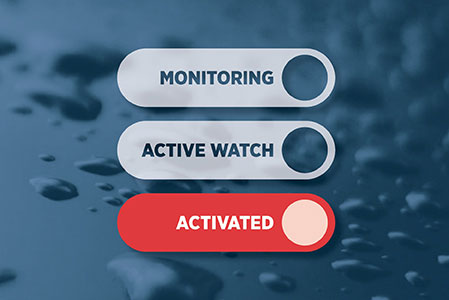
- Status: The weather is severe and there is a high risk of flooding and other natural hazards.
- Action: The flood management team is set up in the Flood Room and the operations team are helping in the field to check flood defences.
What do we do?
We have flood forecasting models that take the MetService weather forecasts and convert that into river flows. We then assess the impacts of those flows. We also have an extensive monitoring network that is regularly watching environmental data (such as river levels, rainfall, wave height etc). You can access this information through our Environmental Data Portal.
We gather and monitor all this information coming in. We then analyse and distribute this data to local agencies, who can use this to make informed decisions about how they support the community.
We will also communicate this directly to communities in low-lying areas as part of our flood warning list.
Flood warning levels
Flooding is the most common natural hazard in Aotearoa. As the climate changes, communities across New Zealand are adapting to meet the challenges of a rising sea level and more frequent, more significant rain events that may cause flooding.
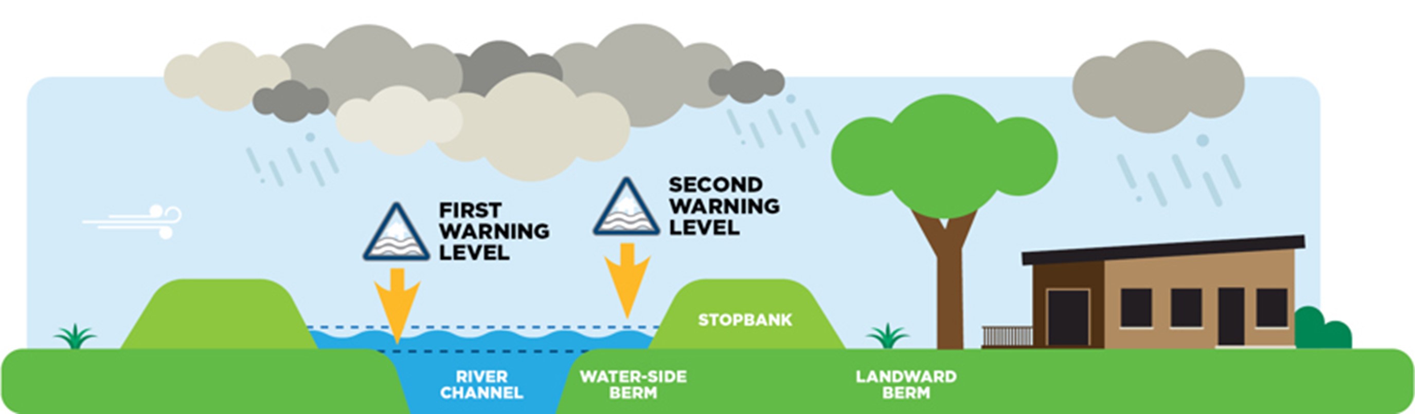
Understanding what’s happening in our backyard is a critical part of how we can help communities become resilient in the face of climate change. That’s why we’ve identified warning levels across our major rivers. These warnings help communities living nearby know what’s happening with river levels during weather events.
- First warning level – the river level has reached its normal channel capacity.
- Second warning level – the river has overtopped the channel banks and has flooded the area next to river (berm). This is still well within the flood defences around the river (such as a stopbank or floodway).
Flood warnings are sent to landowners or the occupiers of properties on low lying rural land next to one of the seven major rivers within or adjacent to the river floodplain (Kaituna, Tarawera, Rangitāiki, Whakatāne, Tauranga, Waioeka, Otara).
The warnings are pre-recorded messages sent via an automated system to a person’s landline and / or mobile phone when the river near them reaches the first or second warning level (more on this below).
The messages include the recommendation to move stock to higher ground, to keep an eye on rainfall and river levels, and to listen to the radio for further updates.
If you believe you own or occupy a low-lying property next to one of the major rivers please email: Engineering@boprc.govt.nz or call 0800 884 880 to discuss the suitability of receiving a flood warning from our team.
Where can I find information during a flood or severe weather?
MetService: Comprehensive weather information and updates
Bay of Plenty Civil Defence: Updates and preparedness support.
- 0800 884 880
- Facebook.com/BOPCivilDefence
Local councils: Information about any potential evacuations and local issues that may arise (i.e. roading, blocked culverts/drains, water/stormwater/sewerage issues:
| Kawerau District Council | (07) 306 9009 | Facebook.com/KawerauDistrictCouncil |
| Ōpōtiki District Council | (07) 315 3030 | Facebook.com/OpotikiDistrictCouncil |
| Rotorua Lakes Council | (07) 348 4199 | Facebook.com/RotoruaLakesCouncil |
| Tauranga City Council | (07) 577 7000 | Facebook.com/TaurangaCityCouncil |
| Western Bay of Plenty District Council | (07) 571 8008 | Facebook.com/westernbaycouncil |
| Whakatāne District Council | (07) 306 0500 | Facebook.com/WhakataneDistrictCouncil |